Partner content: Delivering timely, high-quality location information to Public Safety Answering Points (PSAPs) is critical to emergency services’ mission of saving lives
Caller location regulations advance those interests while balancing them alongside practical considerations for mobile network operators’ (MNOs) implementing successively more sophisticated positioning technologies.
In 2022, the European Emergency Number Association (EENA), in line with the European Parliament’s Commission Delegated Regulation (EU) 2023/444, recommended a “horizontal accuracy estimate of 50m for 80% of all mobile-originated emergency communications.” With the passing of the March 5, 2024 deadline for EU member states to report on the criteria they have adopted in response to the regulation, the focus now shifts to monitoring and enforcement.
As an EENA advisory member since 2011, SS8 has long been engaged with MNOs all over the world as they work to address shortcomings in location information while streamlining compliance. SS8’s platform provides the reliable, high-accuracy location information to meet current and forthcoming regulations effectively and efficiently.
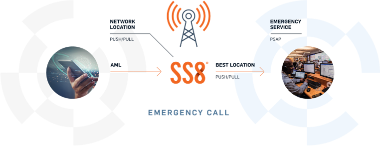
SS8’s LocationWise extracts network-based location data and combines it with handset-derived positioning information. This is the explicit approach recommended by the EU regulation, which states, “The mix of these technologies ensures that even where a handset-derived caller location solution fails to make the caller location information available to the most appropriate PSAP, emergency services can rely on network-based location to usefully come to the end-user’s assistance.”
Inherent limitations of common location methods
Substantial variations exist among regulatory frameworks and MNO location capabilities worldwide. In the EU, legislation in place since 2002 requires cell-level network accuracy or its equivalent. However, this often returns a position within a cell sector of 5km or more. Together with inconsistent implementation across jurisdictions and MNOs, this inherent imprecision results in lost time and wasted resources as first responders search for callers across large areas.
Advanced Mobile Location (AML) uses the computing capabilities of smartphones to improve on cell-level network location. This cost-effective approach, instantiated in the phone OS, uses technologies like GPS, Wi-Fi, and network cell location to provide the best information available, via SMS or HTTPS, to the closest PSAP.
Unfortunately, AML also has significant limitations, leading to an average 40% failure rate that can reach 66% or higher. The technology is limited to smartphones, which have a market penetration of about 85% or so. It is also subject to variations in handset capabilities and settings, as well as potentially out-of-date reference data for Wi-Fi networks and cells. It functions only for active emergency calls initiated by the end user. Moreover, the approach depends on mechanisms provided and maintained by mobile OS providers, and no practical audit trail exists. Monitoring and measurement of success depends on expensive, time-consuming approaches such as drive testing.
Complementing AML with Sub-Cell network location
International standards organizations such as 3GPP and ETSI have issued specifications that enable all mobile networks to provide sub-cell measurement for high-accuracy location. To improve on cell-level location, signal timing information from the serving cell can be used to estimate the distance of a device from the tower, narrowing the possible location area significantly. To refine the location further, geo-multilateration and related techniques based on timing and signal strength information can calculate intersections among the coverage areas of multiple cells in range of the device.

Industry best practices – including the EENA HELP 112 initiative – call for AML and sub-cell location to be used in tandem. This complementary architecture builds on the fact that AML is already widely deployed and adds sub-cell location as a well-established, standards-based evolution of that approach. In this way, high-accuracy, sub-cell network location can validate AML information, as well as offer as safety net when AML fails or provides poor-quality data. Because they do not depend on mobile OS makers, sub-cell approaches are not subject to discontinued vendor support and can be cross-checked against historical network data.
SS8’s LocationWise offers a highly accurate, reliable, and real-time location solution the combines sub-cell network location with device-based positioning. It requires no bespoke hardware and integrates easily into existing networks on bare-metal servers, VMs, or containerized cloud platforms. It provides robust auditability and uses standardized 3GPP and ETSI interfaces that have been defined since the early 2000s, allowing for a vendor-agnostic solution that supports all mobile network generations.
Emergency caller legislation continues to drive improved location capabilities and consistent service, defining more stringent accuracy and reliability requirements. As technologies evolve, MNOs must use these regulatory mandates as guidelines to deploy new solutions that improve emergency response all over the world.
About the author, Stuart Walsh
Stuart Walsh is a consultative technical sales leader with over 30 years of experience helping customers deliver solutions for success. As a technical leader in the Location division of SS8 Networks, Stuart is passionate about introducing next generation solutions and services to network operators and enterprises and driving business growth. Stuart also has a depth of experience in voice and data applications for both Enterprise and Service Provider customers.

You can learn more about Stuart on his LinkedIn profile here.


